CHAPTER ONE
INTRODUCTION
1.1General Statement
Nigeria, the most populous country within West Africa and Organization of Petroleum Exporting Countries (OPEC), has around 208 million inhabitants (Fig. 1.1 and Table 1.1). Abuja, the capital since 1991, has a population of more than one million. English is Nigeria’s official language, lies approximately between latitudes 4°N and 15°N and Longitudes 3°E and 14°E, with a landmass of 923,768 sq. km. (Fig.1.2), the third-biggest country in West Africa by area and 32nd largest in the world, located within the Pan African mobile belt in between the West African and Congo cratons (Obaje, 2009; Fig. 1.2). It is bordered to the north by the Republics of Niger and Chad and to the west by the Republic of Benin (Fig. 1.2). It shares the eastern borders with the Republic of Cameroon right down to the shores of the Atlantic Ocean forming the southern limits of the Nigerian Territory. About 800 km of coastline confers on the country the potentials of a maritime power. vast land is in abundance in Nigeria for agricultural, industrial and commercial activities.
Geopolitically, Nigeria is subdivided into North–South geopolitical dichotomy (Fig. 1.3) and further, for any political exigency, into North–West–East tripartite subdivisions (Fig. 1.4), which coincidentally accommodate the three major tribes (ethnic groups) in Nigeria. The Hausas constitute the major ethnic group in the North; the Yorubas in the West and the Ibos in the East. There are about 250 ethnic groups in total in Nigeria such that each of the regions with its major ethnic group carries a significant percentage of minority ethnic groups (Fig. 1.3). In fact, about 10 ethnic/linguistic groups constitute more than 80% of the population: the other large groups are Tiv, Ibibio, Ijaw, Kanuri, Nupe, Gwari, Igala, Jukun, Idoma, Fulani, Itsekiri, Edo, Urhobo and Ijaw. For further administrative reasons and for the purposes of further political exigencies, the country is grouped into six (6) geopolitical zones (Fig. 1.5).
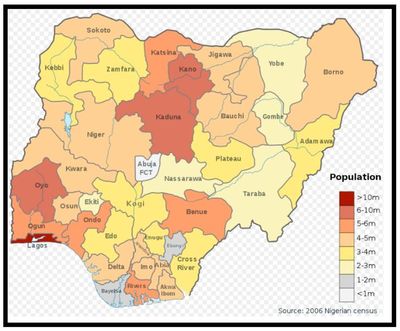
Fig. 1.1.Map of Nigerian states by total population (Source: 2006 census)
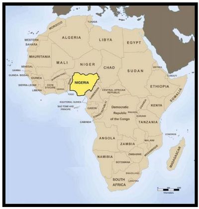
Fig.1.2.Location of Nigeria sandwiched between the West African and the Congo Cratons (Adopted from Obaje, 2009).
Table 1.1 Data of Nigeria as at 2019

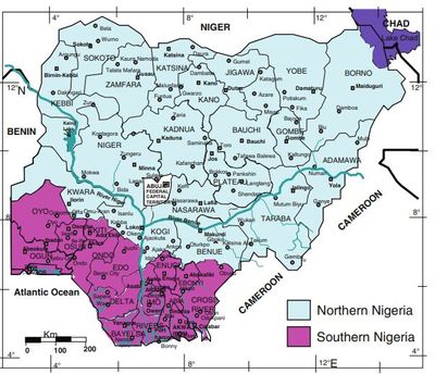
Fig. 1.3.Nigeria’s geopolitical divide in a North - South dichotomy (After Obaje, 2009).
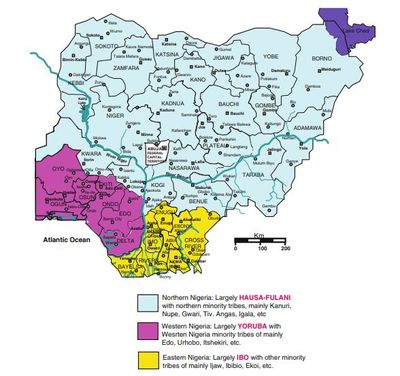
Fig. 1.4.Nigeria’s geopolitical tripartite divide into North, East and West (After Obaje, 2009).
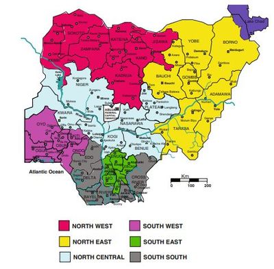
Fig. 1.5.Currently used six geopolitical zones in Nigeria (After Obaje, 2009).
Although Nigeria is wholly within the tropics, its climate varies from the tropical
at the coast to sub-tropical further inland. There are two marked seasons: The rainy
season lasting from April to October and the dry season from November to March.
The maximum temperature in the coastal areas of the south can go up to 37◦C while
the absolute minimum temperature is 10◦C. The climate is drier further north where
extremes of temperature may range from 40◦to 50◦C.
The geology of Nigeria is made up of three major litho-petrological components, namely, the Basement Complex, Younger Granites, and Sedimentary Basins (Fig. 1.6). The Basement Complex, which is Precambrian in age, ismade up of the Migmatite-Gneiss Complex, the Schist Belts and the Older Granites. The Younger Granites comprise several Jurassic magmatic ring complexes centered around Jos and other parts of North-Central Nigeria. They are structurally and petrologically distinct from the Older Granites. The Sedimentary Basins, containing sediment fill of Cretaceous to Tertiary ages, comprise the Niger Delta, the Anambra Basin, the Lower, Middle and Upper Benue Trough, the Chad Basin, the Sokoto Basin, the Mid-Niger (Bida-Nupe) Basin and the Dahomey Basin.
Abundant mineral deposits occur in all the components of Nigerian geology
(Basement, Younger Granites, Sedimentary Basins). Solid mineral deposits of economic significance that include gold, iron ore, cassiterite, columbite, wolframite, pyrochlore, monazite, marble, coal, limestone, clays, barites, lead-zinc, etc, occur in the different geologic segments of Nigeria (Obaje, 2009; Fig. 1.7).
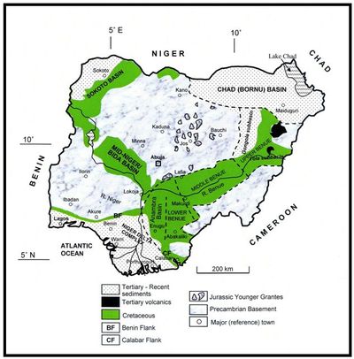
Fig. 1.6.Geological sketch map of Nigeria showing the major geological components: Basement, Younger Granites, and Sedimentary Basins (After Obaje, 2009).
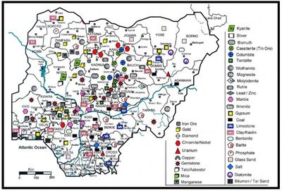
Fig. 1.7:An Overview of the Solid Mineral Resources Distribution Map of Nigeria (Unlikepetroleum, every state in the federation has a fair representation of solid mineral deposits).
The North-Central region of Nigeria comprising Benue, Kogi, Kwara, Nasarawa, Niger, Plateau States along with the Federal Capital Territory (FCT) (Fig. 1.5) is very rich in mineral resources.
This work is in attempt to synthesize all the available data on North-central Nigerian mineral to provide the much-needed information on sourcing, utilization and development in the sector, thus the book shall serve as a very useful companion to all the stakeholders in the minerals sector. It is hoped that the information provided will assist potential investors and students to increase the awareness of entrepreneurs in establishing small-scale or large industries. This will in turn significantly revamp the mineral sector and consequently improve revenue generation from the sector for better economic growth and development. Also provided are details on the latest procedures for obtaining mining rights in Nigeria.
1.2Geology of the North-Central Nigeria
The North-Central region of Nigeria comprising Benue, Kogi, Kwara, Nasarawa, Niger, Plateau States along with the Federal Capital Territory (FCT) (Obaje et al., 2019; Figs. 1.8 and 1.9) is very rich in mineral resources. The geological setting of the region is made up of igneous and metamorphic rocks of the Nigerian Basement Complex (in all the 6 States and the FCT) and sedimentary rocks of the Bida Basin (Niger, Kogi, Kwara, FCT), Middle Benue Trough (Benue, Nasarawa, Plateau) and the Northern Anambra Basin (Kogi, Benue). Fifty percent (50%) of the surface area in Nasarawa and Kogi States are covered with basement complex rocks. In Nasarawa State, the remaining 50% is made up of sedimentary rocks of the Middle Benue Trough while in Kogi State, the remaining 50% is made up of sedimentary rocks of the Southern Bida Basin and the Northern Anambra Basin. Basement Complex rocks cover about 60% of the surface area in Benue, 80% (along with the Younger Granites) in Plateau and 95% in Kwara State (Obaje et al., 2019; Figs. 1.8 and 1.9).
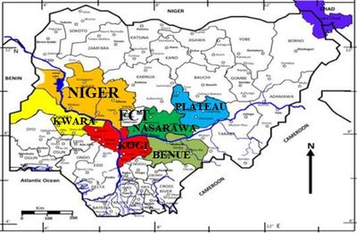
Fig. 1.8. Political map of Nigeria showing the states in the North-Central geopolitical region (After Obaje et al., 2019).
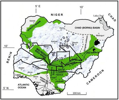
Fig. 1.9.Generalized geological map of Nigeria showing the major geological coversin the states of the North-Central region (Modified after Obaje, 2009).
1.2.1Rock Units in the North-Central Region of Nigeria
1.2.1.1Basement Complex
Obaje (2009) gave a vivid account of the geology of the North-Central to be made up of the Basement Complex and the sedimentary rocks of the Bida, Middle Benue and Northern Anambra Basins (Fig. 1.9). The Nigerian Basement Complex forms a part of the Pan-African mobile belt and lies between the West African and Congo Cratons and south of the Tuareg Shield. It is intruded by the Mesozoic calc-alkaline ring complexes (Younger Granites) of the Jos Plateau and is unconformably overlain by Cretaceous and younger sediments. Within the basement complex of Nigeria, three major petro-lithological units are distinguishable, namely:
-
The Migmatite—Gneiss Complex (MGC)
-
The Schist Belt (Metasedimentary and Metavolcanic rocks)
-
The Older Granites (Pan African granitoids)
The Migmatite—Gneiss Complex
The Migmatite—Gneiss Complexis generally considered as the basement complex sensu stricto (Rahaman, 1988; Dada, 2006; Obaje, 2009) and it is the most widespread of the component units in the Nigerian basement. It has a heterogeneous assemblage comprising migmatites, gneisses, and a series of basic and ultra-basic metamorphosed rocks. They generally occur intricately associated with the Older Granites intruding into them and in some places along with schist belts, but chronologically the Migmatite-Gneiss complexes are oldest (older than Schist Belts older than Older Granites). In aerial cover, migmatite-gneisses are most prominent in Minna, Paiko, Suleija, Tegina and Kagara (Niger State); Keffi, Akwanga and Nasarawa (Nasarawa State); Ajaokuta, Okene, Lokoja East, Kabba, Obajana and Isanlu (Kogi State); Ilorin, Offa, Omuaran (Kwara); Gboko (Benue); along with the Younger Granites in Jos, Pankshin, Langtang (Plateau) (Fig. 1.9).
The Schist Belt (Metasedimentary and Metavolcanic rocks)
According to Dada, (2006), the Schist Belts comprise low grade, metasediment-dominated belts trending N-S which are best developed in the western half of Nigeria. These belts are considered to be Upper Proterozoic supracrustal rocks which have been infolded into the migmatite-gneiss complex. The lithological variations of the schist belts include coarse to fine grained clastics, pelitic schists, phyllites, banded iron formation, carbonate rocks (marbles/dolomitic marbles) and mafic metavolcanics (amphibolites). The belts are confined to a NNE-trending zone of about 300 km wide. The schist belts have been mapped and studied in detail in the following localities: Maru, Anka, Zuru, Kazaure, Kusheriki, Zungeru, Kushaka, IsheyinOyan, Iwo, and Ilesha where they are known to be generally associated with gold mineralization (Obaje, 2009). Within the North-Central, the Zungeru,Kusheriki-Kushaka,Igara and Muro Hills Schist Belts are most prominent in Niger, Kogi and Nasarawa States respectively (Fig. 1.10).
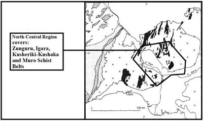
Fig. 1.10. Schist belt localities in North-Central Nigeria within the context of the regional geologyof parts of west Africa(Modified after Wright, 1985).
1. Zungeru-Birnin Gwari 2. Kusheriki-Kushaka 3. Kazaure 4. Wonaka 5. Maru 6. Anka 7. Zuru 8. Iseyin-Oyan River 9. IIesha 10. Igara 11. Muro Hills.
The Older Granites (Pan African Granitoids)
The term Older Granite was introduced by Falconer (1911) to distinguish the deep-seated, often concordant or semi-concordant granites of the Basement Complex from the high-level, highly discordant tin-bearing granites of Northern Nigeria. The Older Granites are believed to be pre-, syn- and post-tectonic rocks which cut both the migmatite-gneiss-quartzite complex and the schist belts. The rocks of this suite range in composition from tonalites and diorites through granodiorites to true granites and syenites. The Older Granites occur intricately associated with the Migmatite-Gneiss Complex and the Schist Belts into which they generally intruded. Older Granite rocks therefore occur in most places where rocks of the Migmatite-Gneiss Complex or of the Schist Belt occur. In the study area, Older Granites are prominent in Minna, Paiko, Kudna, Suleija, Kagara in Niger State; Keffi, Akwanga, Panda in Nasarawa State and Lokoja East, Okene and Kabba in Kogi State; and the same localities listed for Migmatite-Gneiss Complexes for Kwara, Benue and Plateau State.
The Younger Granites
The Precambrian Basement Complex rocks of North-Central Nigeria are intruded by ring complexes and associated bodies of Jurassic age. Similar bodies occur in Air, Niger Republic. The Younger Granites are majorly concentrated around Jos represented by the prominent Jos-Bukuru, Rukuba, Amo-Buji, Ganawuri, Sara-Fier complexes, amongst others (Fig. 1.11; Obajeet al., 2019). The Afu and Mada complexes are in Nasarawa State. The Nigerian and Niger Younger Granites form a north-south trending zone and the Benue Trough cuts obliquely across the trend. This zone is parallel to the main Pan-African trends in the basement, indicating control by earlier structures. It also lies on a continuation of the African continental margin to the south and possibly formed in a region of crustal arching developed prior to the separation of the African and American plates in the Cretaceous. The Younger Granites show many features of classical ring structures. Burke and Whiteman (1973) suggested that they mark the site of an r-r-r triple junction which failed to develop because large volumes of igneous rocks were produced. Whiteman (1982) and Turner (1983) think that the Jurassic igneous activity is part of a progression which involved the development of the Benue Trough and culminated in the formation of the Cameroun Volcanic Zone. Major characteristics of the Younger Granites are their petrological peralkaline affinities (sodic-potassic feldspars; sodic-potassic amphiboles, e.g. arfvedsonite, riebeckite; and sodic-potassic pyroxenes, e.g. aegirine); as compared the calc-alkaline and per-aluminous affinities of Older Granites; their structural cross-cutting, discordant, and steeply occurring hilly outcrops in the form of ring dykes and cone sheets in contrast to the generally flat-lying nature of the Older Granites (Fig. 1.12; Obaje, 2009) their anorogenic occurrence in contrast to the orogenic origin of the Older Granites, and their stratigraphical Jurassic age as compared to the Precambrian age of the Older Granites. The age of the Younger Granites decreases from south to north. The Younger Granites are majorly associated with Tin (Cassiterite) mineralization. Other minerals associated with the Younger Granites are Columbite, Monazite, Wolframite, Pyrochlore and large clay deposits (Lar et al., 2007; Obajeet al., 2019).
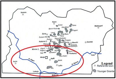
Fig. 1.11.Major Younger Granites Localities in Nigeria showing the major states covered in the North-Central region (Modified after Obaje, 2009).
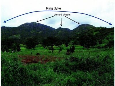
Fig. 1.12.A portion of the Mada Younger Granite Complex near Akwanga in Nasarawa State.
Note the migrating domed sheets and the circular nature of the Complex
(Adapted from Obaje, 2009).
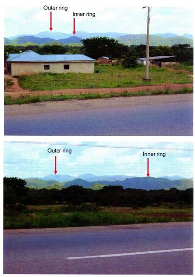
Fig. 1.3.Different views of the Jos-Bukuru Younger Granites Complex.(Viewed approaching Jos from Tilde Fulani). Note outer ring and inner ring.(Adapted from Obaje, 2009).
1.2.1.2Sedimentary Rocks / Sedimentary Basins
Based on the works of Adeleye (1974); Braide (1992a and b); Obaje et al. (2004), sedimentary rocks in the North-Central comprise Cretaceous successions in the Northern Bida Basin (Niger, Kwara), the Middle Benue Trough (Benue, Nasarawa, Plateau), the Southern Bida Basin (Kogi) and Northern Anambra Basin (Kogi, Benue) (Fig. 1.9). The stratigraphic successions documented in Obaje (2009) are shown in Figs. 1.13 to 1.15.
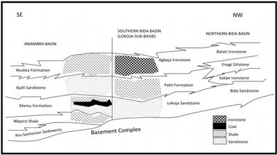
Fig. 1.13.Stratigraphic successions in the Bida basin correlated to the Anambra basin covering Niger and Kogi states (after Obaje, 2009).

Fig. 1.14.Stratigraphic successions in the Nasarawa State portion of the Middle Benue Trough (after Obaje, 2009).
Some Annextures on the Middle Benue Trough as described by Obaje et al. (2006)
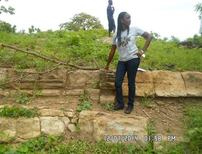
Sandstone of the Awe Formation (Cenomanian) deposited under high tidal influence at the Old Awe village (Middle Benue Trough), Nasarawa State
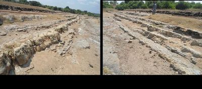
Laterally extensive tidally influenced sandstone beds of the Awe Formation (Cenomanian) at the salt mining pond area at Ribi Village (Middle Benue Trough), Nasarawa State
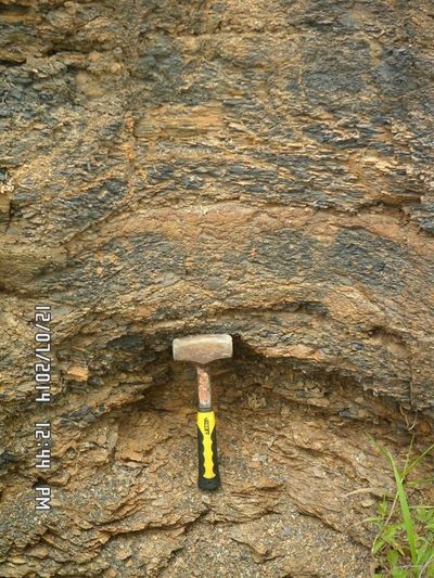
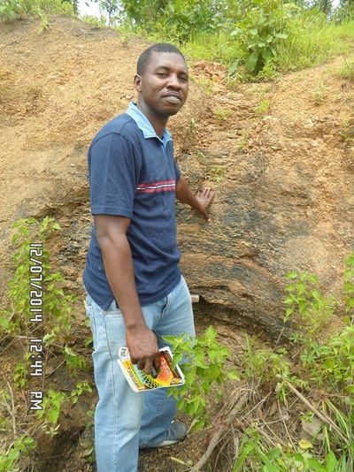
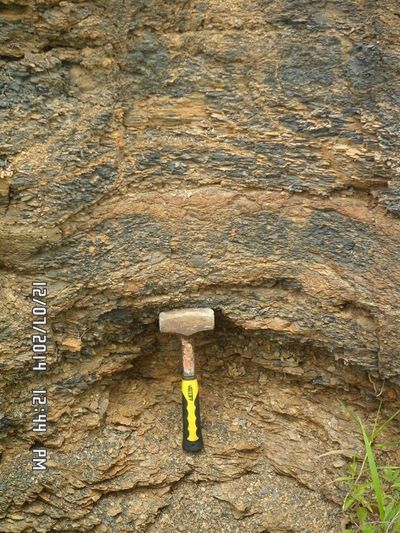
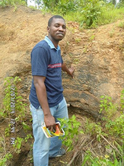
Carbonaceous shales within the Keana Formation (Cenomanian) in a gully section at Keana (Middle Benue Trough), Nasarawa State
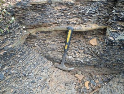
Highly carbonaceous shales (baked) of the Ezeaku Formation (Cenomanian) at the entrance bridge at Ribi Village (Middle Benue Trough), Nasarawa State
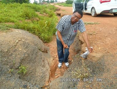
Highly carbonaceous shales (baked) of the Ezeaku Formation (Cenomanian) at the entrance bridge at Ribi Village (Middle Benue Trough), Nasarawa State
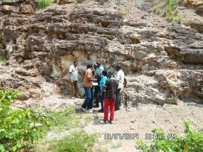
Clay members of the Keana Formation exposed extensively on the Obi-Keana road(Middle Benue Trough), Nasarawa State
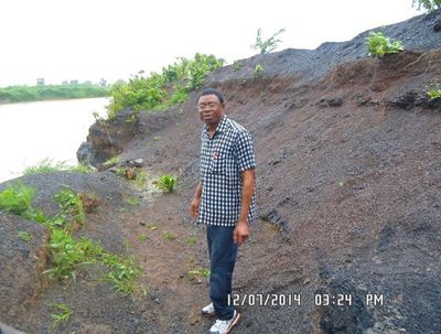
Coal/shaley coal of Lafia-Obi coal deposits within the Awgu Formation (Turonian-Coniacian) at the River Dep bank at Jangwa (Middle Benue Trough), Nasarawa State
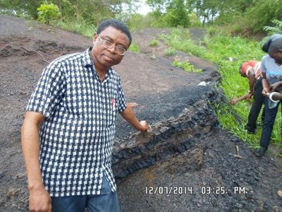
Coal bands of Lafia-Obi coal deposit within the Awgu Formation (Turonian-Coniacian) at the River Dep bank at Jangwa (Middle Benue Trough), Nasarawa State
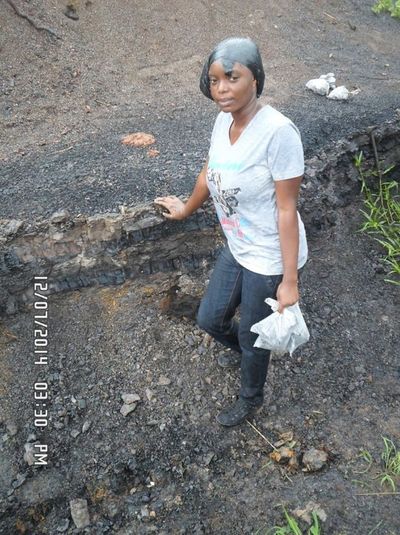
Coal bands of Lafia-Obi coal deposit within the Awgu Formation (Turonian-Coniacian)
at the River Dep bank at Jangwa (Middle Benue Trough), Nasarawa State
dip
dip
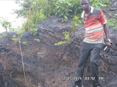
Coal bands of Lafia-Obi coal deposit within the Awgu Formation (Turonian-Coniacian) at the River Dep bank at Jangwa (Middle Benue Trough), Nasarawa State
(Note the high dip resulting from the Santonian deformation)
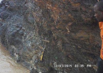
Thicker coal layer
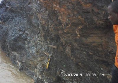
Thicker coal layer
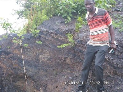
A thicker coal layer of the Lafia-Obi coal deposit within the Awgu Formation (Turonian-Coniacian) at the River Dep bank at Jangwa (Middle Benue Trough), Nasarawa State
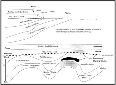
Fig. 1.15.Stratigraphic successions in Kogi State portion of the Anambra Basin (after Obaje, 2009).
Some Annexures on the Anambra Basin as described by Obaje et al. (2006)
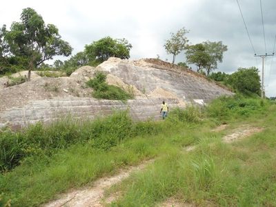
A section of the clayey member of the Mamu Formation at Ojodu, on the Ajaokuta-Anyigba road, Kogi State, Northern Anambra Basin
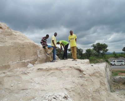
Logging the clayey member of the Mamu Formation at Ojodu, Kogi State, Northern Anambra Basin (Note some mining of the clay has taken place)
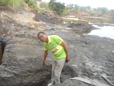
Coal/coaly shale/shaley coal deposit within the Mamu Formation at the Okaba coal mine, Northern Anambra Basin
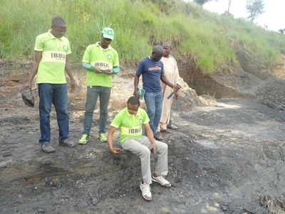
Coal/coaly shale/shaley coal deposit within the Mamu Formation at the Okaba coal mine, Northern Anambra Basin
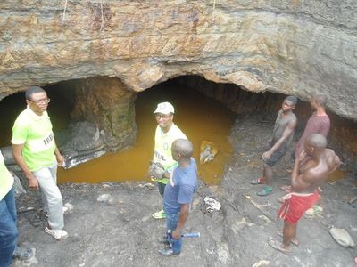
Near surface /underground mining of coal deposits within the Mamu Formation at the Okaba coal mine, Northern Anambra Basin
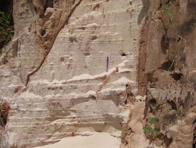
A section of the very finely sorted whitish beach sands of Ajalli Sandstone at Ochadamu, on the Ajaokuta-Anyigba road, Kogi State, Northern Anambra Basin